After the success of the last bikepacking trip through Waikaremoana to Rotorua, Steve was easily persuaded to join me on a smaller trip closer to home. I’d been studying the topo map of the hills behind work, of which I’d ridden into a little way, and thought I could string a good overnighter together – camping at a DOC campsite on the Mohaka River. A fine sunny weekend was forecast, the only possible problem there being the thirty-plus temperatures.
Saturday morning was spent doing chores and shopping for food. So, it wasn’t until after one o’clock we set off north from Napier. The ride around the coast was as stunning as ever – even though it’s the way I ride to work often, it felt quite different on the weekend with a loaded bike heading off on an adventure.
 All smiles at the prospect of exploring somewhere new – Steve has now perfected the riding selfie, no thumbs in this one.
Up Waipunga Road, we were headed for gravel roads that I had at least pedalled over previously. The heat wasn’t unbearable with a bit of motion-induced breeze, but definitely it was hot. Reaching the end of Waipunga Road, we were atop Darkys Spur and ready to zoom down to Waikoau. I insisted we stop a couple of times on the way down to take in the view of the hills and the gravel road winding its way down to the valley floor. Looking at that inviting topo map, I think there are more, smaller, adventures to be had exploring around here.


Passing through the unexpected and decidedly odd ex-Railways village of Waikoau, we were back on sealed road heading down the valley to the Wairoa road. There we knew was the Tutira Store – our last chance to refuel. It was stupidly hot in the store – which went someway to explaining why the woman behind the counter was so grumpy when we asked to fill water bottles, after buying delicious ice creams. I was not surprised to see a For Sale sign up – looking after customers was not a talent on display. We filled our water bottles at the charming little school over the road and headed north-east & inland.
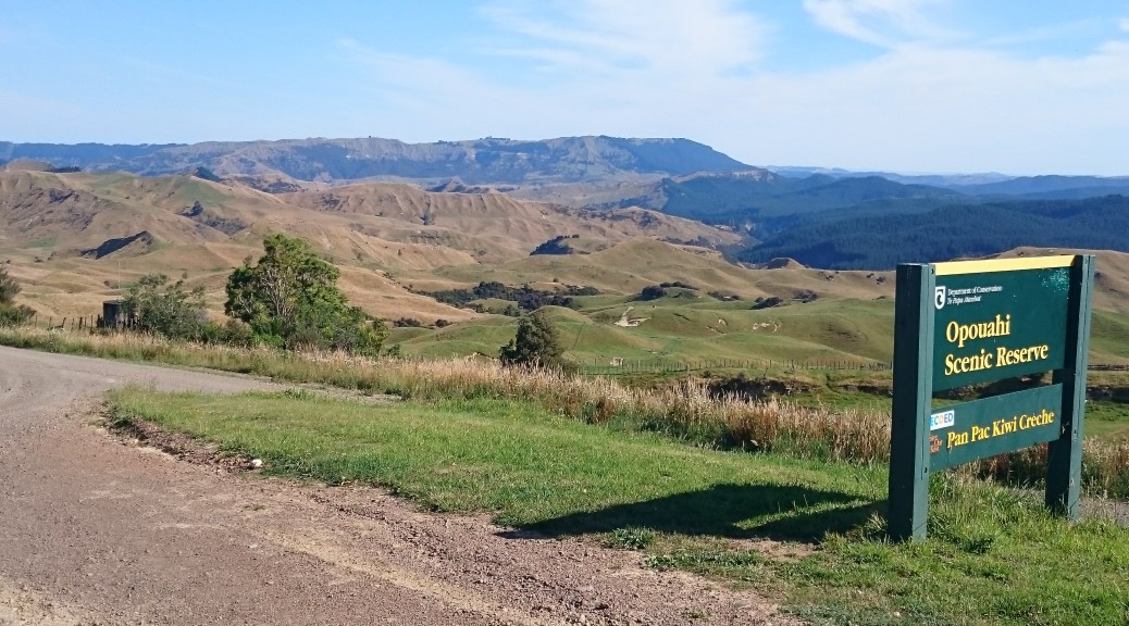
I hadn’t realised there were so many walking tracks and other things to see up this seemingly innocuous country road. Forced to stop at Opouahi Scenic Reserve to wait for a mob of lambs to be herded down the road, we found a nice little lake surrounded by bush and a kiwi (the bird, not the fruit) creche – for which our company seems to be the naming sponsor, who knew?
 While we waited we could look back over the valley we’d just ridden down to Darkys Spur – you can just see the cutting for the road heading down and right from the centre of the ridge.
 To my surprise, I got closer to the lake than Steve – he didn’t have a swim at all during our ride. (c.f. the three of the last trip)
 Just a NZ backcountry traffic jam.

The steady climbing on the well-surfaced gravel road continued as we started to ride through more bush than farmland. Interesting rocky outcrops started to appear on the small bluffs. We avoided being accidentally shot by a farmer out hunting rabbits as dusk settled in.
 I didn’t know these signs actually existed – I have a small plastic version that someone (Adele) sent me while I was overseas, I suspect to make me homesick.
There were yet more trailheads to pass – I must come back one day when I’ve run out of places to ride and check out some of the hiking trails. Reaching our highest point for the day, about 800 m above seal level, the views opened up to the north. In the early evening light I’d really been enjoying the climb and this just topped it off. We could see a long way north. I checked my GPS’s list of “cities” nearby – we were only forty kilometres from Tuai, a village we rode through on the Waikaremoana trip! Sometimes I’m surprised by the distance one can cover on a bike with minimal effort – or maybe, it’s just NZ really is quite small.

 I’d enjoyed seeing many different uses of the land on this ride so close to the city. Now we were definitely heading into plantation forest.
We reached our northern-most point on the route and turned onto Waitara Road – obviously a haul road for logging trucks, it was the widest gravel road I’ve seen in a long time. We were hauling too down there as we lost a lot of altitude. Unfortunately, after so many hours in the heat there were a few not-insubstantial climbs to surmount before we finally got to the turnoff to the campsite. But the climbing was not over quite yet – eventually, we rolled down the final descent just before eight o’clock.
For an isolated campsite inaccessible to motorhomes, campervans and small cars – it was pretty busy. There was enough daylight left to make camp, head down to the Mohaka to cool and wash off the day’s dust and sunscreen, clean up some severe food leakage in my cooking set and make a well-earned dinner. A warm night with a big moon, it was plenty bright. Steve had no qualms in settling for the bivy bag, while I took my little tent. All slept well as it turned out we’d done more climbing in significantly less distance than the Waikaremoana trip – I wasn’t expecting that.
I think I even made the outrageous claim that I enjoyed that day’s riding more than the Waikaremoana trip – & that was fantastic. Perhaps it was just the living-in-the-moment thing that made it seem so good. But after a couple of days, it still seems that good – maybe because it was a route made up just to go & see what was out there and not one I’d got out of a book. Anyway, I’ll stop trying to rationalise it – it was an excellent afternoon of bikepacking finding new places so close to home.
However, due to leaving it too late in being persuaded in trying to get permission (from a forest owner and a farmer) to access an alternative, more interesting and lower-traffic route home, Sunday was only good without being exceptional. Still, I can’t complain about being out on a bike in the sun – I’ll just have to do the trip again (which I’d be more than happy to do) and organise the land access earlier to make the return to Napier more enjoyable.
Sunday morning continued on gravel with a fair climb up from the river to get us going. Soon we were back on the sealed road and came across the more accessible Glenfalls Campsite – it was very popular, I remember now that it is still school holidays. Our morning got a little more social as first we chatted with a Canadian cycle-tourist (who’d braved the length of the Napier-Taupo, which I’m not keen on doing) and then dropped in to visit someone from work – who just happened to live at the turn-off to the forest I want to ride through next time.
 Glenfalls looks a popular place to camp.
From there, it was on the highway for twenty-five kilometres – consisting of one big climb and then a long descent towards the coast. The Sunday morning traffic wasn’t too bad and I pootled up the hill OK. We turned off to take backroads back to the city – we found out we missed a four-car pile-up near this intersection by half an hour, it closed the road. Thankfully the diverted traffic never caught up to us on these smaller roads as we rolled into Napier happy campers (quite literally).
It didn’t take long before my eyes turned back to the local topo maps to start planning more loops in the hills – so much to explore when you live somewhere new!