Category Archives: NZ

NITT 5 – Taumaranui to Ohakuri Dam

A leisurely start to the day with twenty-five kilometres of quiet backroads, with only the slightest of inclines as we followed the Ongarue River upstream and turned off to begin the Timber Trail.

There’s that railway again, for the last time on this trip.

Both Pete and I were looking forward to riding the Timber Trail in the reverse, south to north, direction to that which is normal. With a gentle southerly behind us, it didn’t disappoint. One of the reasons I prefer riding it in this direction is that the part of the trail that is in the worst condition (up to the Ongarue Spiral) is over and done with straightaway and one can forget about how poorly maintained and uninspiring that section is; going the other direction, it’s such a disappointment to finish an otherwise great day on.

Suspension bridges galore still delight – such vast gaps in terrain they bridge, with the native bush-clad valleys so far below. With both of us having ridden this trail plenty of times, photos are few and far between. One of the highlights was stopping in and checking out the new Camp Epic – and not just because the kettle was on and we got tea and coffee. All the tents spread around the big clearing and campfire, over a dozen, form part of quite the facility (cooking shelter, toilet and shower block, and plenty of room to pitch your own tent) – a worthy addition to the limited facilities on the trail. As always, maybe one day I’ll ride the trail more slowly and, therefore, get to stay here. I commented that the tents, not so much the surroundings, reminded me of being on safari – turns out all the tents were imported from South Africa, so that explains that.

Trail traffic increased later in the afternoon, as we came across a few bikepackers and many that were riding the trail over two days – either stopping at the lodge or Camp Epic. The views from the high point on Pureora over to Lake Taupo were some of the clearest we’ve both seen – often it’s either dark or clagged in when I’ve been up there. From there, the chief reason that I prefer the direction we were heading – a stonking great ten kilometre downhill to finish. Riding the last few kilometres, after it’s flattened out a bit, through pristine native bush, having to pedal a bit but able to hold a lot of speed, is my favourite piece of semi-technical mountain-biking on the trail; such fun to finish.

While that was a lot of the day’s climbing done, it was far warmer down a few hundred metres lower and out from underneath the canopy. As Pete educated me a bit more about the timing of when this forest was saved from logging and when various hiking trails were formed and huts built, we climbed up to the amusing “Centre of the North Island” (a piece of cardboard!). The notorious Arataki Swing Bridge had passed its load test a day or two before, so we didn’t have to take a large detour. Instead it was back past the place where I was overcome with heat stroke symptoms three months before, I’m unsure how I’d managed to climb up and get to Pureora – it sure was a long downhill to get to the spot.

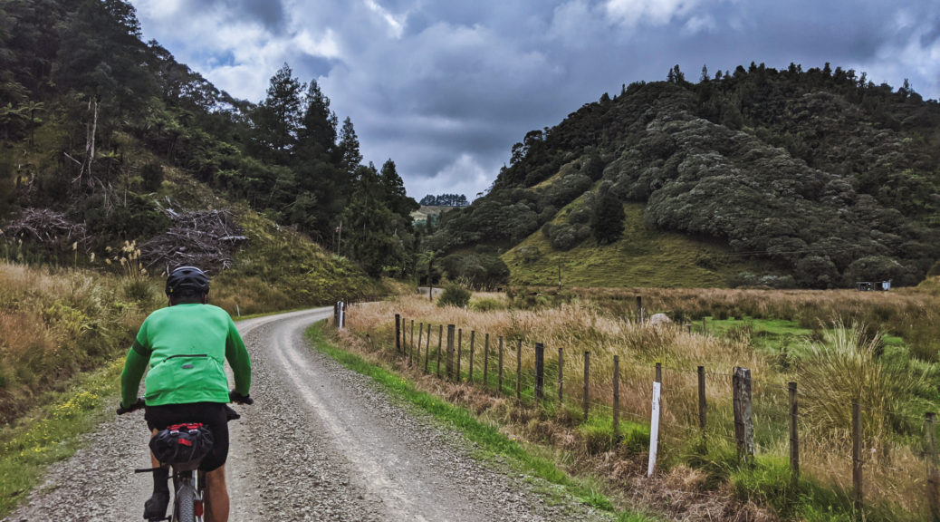
Surviving the bridge, I only managed to jam my thumb between my handlebars and an upright once, there was a little pushing up to the road end before a quick sealed, descent to Whakamaru for fish, burgers, milkshakes, ice cream and resupply. While it hadn’t been a big day for distance, such a long trail can take it out of you. We planned to ride what I consider to be one of the easiest and most pleasant sections of the Waikato River Trails for twenty-five kilometres to a short stretch on State Highway One before finding somewhere to bivy overnight.

A glorious evening, the mighty Waikato was becalmed. Although I’d only ridden this section once, and enjoyed it so, and knew there was little elevation gain to be had – I’d long ago learnt that one underestimates this collection of trails at your own peril, especially on a loaded bike at the end of a long day. So it was, the tiny pinch climbs kept coming – hitting us one after the other for much of the first half of the section. But it was such a stunning evening, it could hardly have gotten to us. Things flattened out around some fields and we could hold some speed, eventually popping out on the highway a little after nine o’clock.

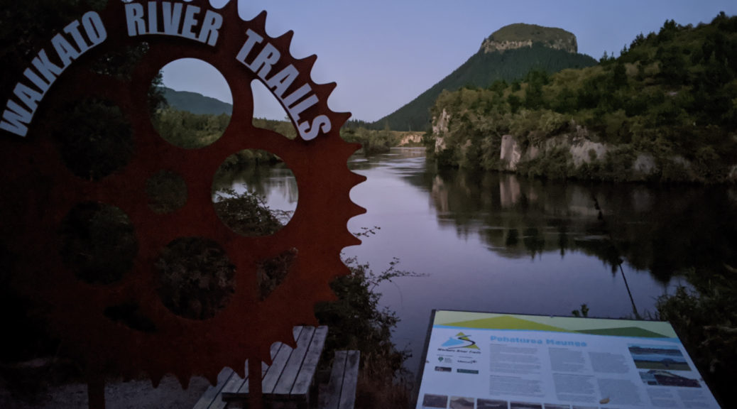
The end of the trail would come close to Pohaturoa, which was just over the river from the trailhead.

With Waitangi Day the following day, a Thursday, I was expecting the highway to be busy with traffic heading south from Auckland for a four-day weekend. It really wasn’t that bad, the four kilometres having ample shoulder. Ten more minutes and we’d dropped down to the river, crossed the Ohakuri Dam and found a very quiet and sheltered spot to camp the night. A shorter day for distance, there was much riding in that 173 km – over a hundred of them were trail; another pleasing day, we figured we’d completed the difficult half of our North Island Traverse and were well on schedule to finish within four days.

NITT 4 – New Plymouth to Taumaranui

Sneaking out before the house woke, an easy roll down through the city took us to the brilliant Coastal Pathway – always great seeing so many using such facilities, especially early in the morning.

The day promised to be cloudier than the previous few.

No views through the bridge of Taranaki today.

Leaving the pathway and the coastal area, we headed through Bell Block to ride on backroads looping back around to the highway at Urenui. Skirting a light industrial area was only mildly interesting because I saw plants where various people I’ve met on process safety courses over the last four years work. Unfortunately the road which is designated as part of the NZ Cycle Trail seems to be a main arterial route for many trucks going south from Bell Block; with no shoulder and little visibility due to the lumpiness of the road, it was awful and at times frightening. Things improved a little past Lepperton through farmland, but by the time the twenty-five kilometre detour was done we’d long since decided we’d have been better off on the highway – which at least has a decent shoulder and less alarming traffic.

A large cooked second-breakfast and resupply at Urenui was just the ticket before getting onto quiet country roads, following the sedate Urenui River valley upstream. The farming was back to looking marginal, and in places the land was slowly reverting to scrub and bush. Past Okoki, where there’s a useful looking Outdoor Pursuits place homed in the old school (camping, water, showers, maybe a pool) the gravel started and excellent it was too.

Cruising up a two hundred metre climb; flowering kanuka was also a feature of the day.

Through the first tunnel of the day, we cruised down towards Uruti. At the junction of Moki Rd (the other end of which I’d passed two days ago; the centre section is a gnarly paper road that I rode four years ago on a tiring day ride), we met a local who enthused at length about the beauty of the area, and interest all the various hills hold for him. From what I’d seen so far, I could not but agree.

Climbing Moki Rd, heading for the second tunnel of the day.

Now past noon, the cloud cover and gentle westerly were most appreciated. The prevailing wind was one of the reasons we were riding between capes west to east; another main reason was the Timber Trail is, I think, far better in that direction – contrary to prevailing wisdom. By now, it was clear to me that I was mostly noticeably behind Pete – as can be seen in the photos. Usually we’re about the same pace – but I did have an extra two and a half big days of riding almost five hundred kilometres in my legs. So I wasn’t put-out, or disappointed to be slower; but it was a bit odd to suddenly have to adjust to riding with someone else and the effect on pacing and stops that has.

Tunnel number two for the day.

Dropping down to the junction with Kiwi Road, we headed north on the section of our route shared from that trip four years ago. Funny, reading that trip report back I hardly mentioned the steep climb that would have us sweating for the next half an hour. A fast descent took half our elevation as we met a bit of a flat valley and our third tunnel of the day and a drop back down to sea-level.

A good sign as we head up Kiwi Rd; we saw little traffic, as had been the case since Urenui.

Tunnel #3.

Joining the Mega GGG route from 2017, we were heading inland and I failed to recognise it in this direction! Stopping in the shade at Kotare and snacking on roadside blackberries, it was time for a bit of a rest before the four hundred metre climb to Waitaanga. If we’d continued on the road we’d been on, we would have eventually reached the other end of Moki Rd and the Forgotten World Highway – looking at the map now, there’s clearly more scope for me to explore new places.

The hour of climbing to Waitaanga was leisurely enough starting out beside the Mangatawa Stream before rearing up a bit to crest the hills and go across the Waitaanga plateau. Not much left in here these days, we rode through and hit the steep climb over to Ohura. It wasn’t as bad as I remember, being reasonably flat at the top before bombing down to Ohura. On her day off, the now-legendary-in-North-Island-bikepacking Michelle opened up her Fiesta Food Cart just for us, plying us with cooling watermelon, yoghurt and cold drinks before a piled plate of Mexican food and quesadillas. Much needed nourishment and rest in the shade.

Duck!

As we sat, the shade very quickly came from a dark bank of clouds rolling in. With the tail end of a storm that had just dumped rain further south (extensive flooding in Milford Sounds – that storm) approaching, we booked a motel room in Taumaranui. We just had to get over two significant climbs and cover the forty-five kilometres left for the day. I’d only ridden this section in the opposite direction on last year’s Mega and I didn’t remember much except hills and good looking, but cloud covered, steep farmland.

It turned out the first half was very pleasant valley floor riding back to the Forgotten World Highway. One of those times where the river besides you is dropping very slowly, but the road is gently climbing if not flat. To my bewilderment, we passed an ad hoc polo match – with horses and everything! My mind still boggles, not a common scene in NZ – not even an uncommon scene, more unheard of.

Off the FWH, we hit fresh, deep and uncompacted gravel for a few tedious kilometres. Near the end of another long day, weary legs tried their best to attack it and get it over with – but really they just pedalled slowly through. As darkness fell and we wound our way up the last climb of the day, the rain started lightly – which helped regulate the temperature somewhat. At the top of the hill, we layered up for the descent and phoned the motel to advise we were still on our way, not lost – just a little later than I’d previously estimated.

Half an hour straight down into town was decidedly the coldest and wettest I was for the whole trip – which, in the scheme of things, was exceptionally good. Strangely, I began to crave McDonald’s – perhaps because I knew it would be open. But the gas station next door was also open – a late night pie and chocolate milk satisfied my hunger. The Alexander Spa Motel is recommended for being most accommodating to cyclists, and sufficiently far from the railway to be quiet. Unfortunately, rest won out over a nice spa; on a warm evening, clothes dried easily as we slept soundly.

I definitely wasn’t my strongest or most energetic that day, but look back at it now and see that there was a fair amount of climbing and plenty of new roads and sights – another great day on my NITT.

NITT 3 – Tokirima to New Plymouth

Gone by six, I was soon back on the Forgotten World Highway as an overcast day dawned. Having driven the FWH a few times, the scenery was nice but my breath was not taken as previously. There are a few small climbs, but also a lot of valley riding was pretty easy going. Unfortunately, for backcountry cycling, all but twelve kilometres of the road is sealed now; that part which is still gravel was in pretty horrible condition. A symptom of the unexpected number of logging trucks? Perhaps; it’s still surprising to me that I saw most logging trucks of the entire trip through these backblocks.

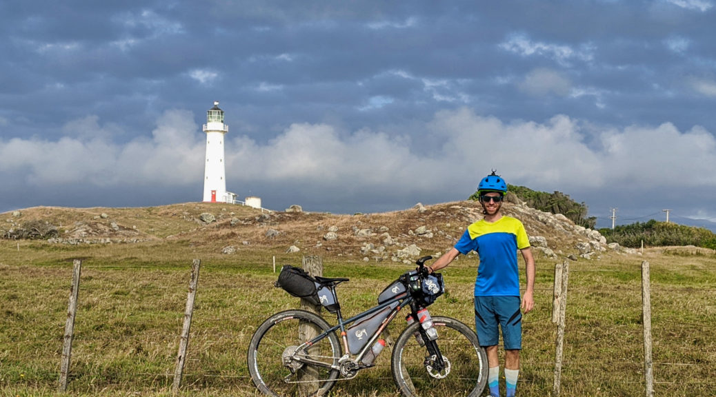
Hobbit Hole, the sign says; the tunnel on the FWH.

The road finds the old railway at Tahora (about 40 km into my day) and ran close to it for much of time until I turned off thirty-five kilometres later. The exception being the railway gets tunnels at far lower elevation than the saddles the road passes over.

Approaching Tahora Saddle – rails stay low.

The hotel wasn’t really open at nine-thirty, but they rustled up bacon and eggs for me nonetheless – supreme.

Reaching the last significant saddle heading west on the FWH, it was time to turn north and find some better gravel. My route stayed about five kilometres north of the main road heading for Stratford. My word, the hills, gravel backroads, farming scenes and views were especially noteworthy. Eventually, Taranaki came into view too; it was one of those rare clear days where at one particular spot I could see both Ruapehu and Taranaki, although not simultaneously – being between them and all.

Climbing from Matau over to Huiroa, I was pleased by the sudden appearance of a tunnel just when I was beginning to wonder how the road would get over the ever-steepening hillside. But I was surprised to meet a pedestrian just standing there; more so, when we found we worked at NZ Steel at the same time and previously only had one degree of separation. Unusually, I thought, he and his wife were staking out the tunnel to photograph logging trucks; I’d seen some evidence of recent felling, but no cartage on this road.

I rode through the tunnel doing my best impression of a logging truck…

…and got this photo for my efforts.

Down in sheep farming country now, I spotted a mob being driven up the road. In no rush, there was enough time to dive off down a driveway and seek shade from the quickly warming afternoon and let the flock pass without me troubling them. Shortly after, stopping for water at a farm house, I was not surprised to find the day had quickly climbed into the thirties.

Sometimes you get to see Taranaki.

Warming a bit much, the last little stretch into Stratford was a bit of a drag – but the cold, quiet and empty Subway was a good place to recharge and refuel. Pete got in touch, and we figured I’d complete the sixty kilometres around the southern side of the mountain to Cape Egmont to meet him in three hours. Planning this route, I knew this stretch of road wouldn’t be particularly fun – but it meant I’d ride around Taranaki, and it wasn’t a highway.

The views stayed, and on the busy route between Ohakune and Stratford I had to keep my wits about me. The road climbed gradually, by far the highest I’d been all day, but was lumpy as it did so – all those streams and rivers running off the slopes had to be crossed. Progressing, I turned more and more into the NWer. Nothing for it but to put my head down and ride; knowing I’d soon be dropping down to sea level was some consolation.

The Tasman Sea tantalisingly close and less traffic once I was off the route between towns.

Descending to the sea, I finally found out exactly where Parihaka is. The last section was a little longer than I expected, I met Pete just after six o’clock where I was welcomed with a large chocolate muffin – that certainly hit the spot. A bit of a break to savour traversing the North Island in bang-on two and a half days (~480 km, 8000 m of climbing), riding some fantastic trails and backroads for the first time – excellent weather helped, and even the westerly oriented winds weren’t too bad, generally.

So, that’s the heading-west side of the trip done.

Less than quarter of an hour later, there really wasn’t much else to do (the lighthouse was shut) but get on the bikes and start the journey to East Cape. We thought we’d get to New Plymouth for before dark. Back up the east-west roads I’d just descended wasn’t too bad; actually rather pleasant as they were quiet enough to enable much chatting and the wind was now helpful.

Climbing up to Carrington Rd, which would take us twenty-five kilometres right into the city, it loosely followed the 450 m contour line. A skinny, sealed road with a moss median strip it was often a tunnel of native forest. Sublime riding on that evening, one of the highlights of the day and an excellent way to start Pete’s North Island Traverse route.

Before nine we were being welcomed, with admittedly short notice, in to Jacqui and Dan’s home for much appreciated real food and beds. Quite pleased with my first day of well over two hundred kilometres for some time and not being particularly sore, sleep came easily.

NITT 2 – Mataroa to Tokirima

A day utterly dominated by the North Island Main Trunk (NIMT). It started by the night being dominated so, at least half a dozen trains thundering past kept me from sustained sleep – but I was rested enough to have fed the school cat again, packed up and got riding before dawn.

Heading out of town, the road briefly followed the tracks – but they soon headed north as I went west.

Quiet country roads had the expected serving of climbs and descents as I warmed. Short, pleasant sections of gravel came, went, came again and eventually disappeared.

Turning north, I was heading straight for Ruapehu – it far closer than the previous day.

Crossing the rails again, I joined the service road that is listed as an alternative for riding on the highway. It started out mild enough, I enjoyed passing motor vehicles as they carefully negotiated the large potholes. At times ballast had subsided from the railway, making for some deep chunky gravel. Approaching halfway to Ohakune, it got worse: there was a deep, swift stream crossing I wasn’t keen on, so that forced me onto a narrow rail bridge; then the service road had been freshly laid with uncompacted gravel for kilometres. Eventually I tired of that and bailed through a farm to the highway – I suggest the service road is avoided on a bike.

In Ohakune for a big, long breakfast I managed to avoid the draw of all things carrot-themed. The Old Coach Road trail held a far stronger attraction. Based on the old coach road (rather obviously) that for some years in the early twentieth century linked the two unconnected ends of the NIMT, it had clearly been well built. Over a hundred years later, the stone laid to bench the track and weatherproof it was still obvious. Routing of railways being even more dependent than bike trails on making the best use of the topography, the interpretative panels were a fascinating study in history, geography, engineering and perseverance in trying conditions.

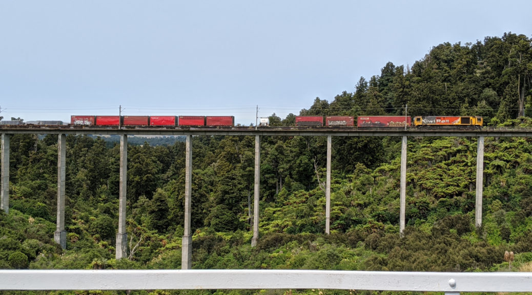
A more recent, straighter, viaduct built to cater for increased speed of new trains.

The old viaduct had been restored to allow human-powered passage.

I was surprised at just how short the trains were; I expect, and hope, there’s some technical reason for that.

The riding was most pleasant too, the green cover keeping the heat away.

Another closed viaduct.

This sign gets the day’s “bleedingly obvious” prize.

The northern trailhead deposits one in Horopito, home to a car wrecker’s yard since the forties it’s quite the juxtaposition with all the surrounds.

Another Ruapehu shot, this time with decaying transport relics.

One of the more well known of such establishments in NZ, it’s been used as a location for quintessential Kiwi films such as Smash Palace, Goodbye Pork Pie and Hunt for the Wilderpeople (not majestical, however).

Twenty kilometres of undulating highway took me north to National Park, a late lunch and resupply for the next eighty kilometres to Taumaranui. Alongside the NIMT line again, the tourist train (Auckland – Wellington) rolled past, I must do that trip one day.

For a change, Ngauruhoe

For the second time in the day, I was excited to get to ride for the first time a trail that I’ve known of for years – but never had occasion to explore. Fisher’s Track would, in quick fashion, drop through all the elevation I’d been gradually gaining over the day and much of the previous day’s too. A paper road through native bush and then scrubby farmland, it was also well formed and, in the dry weather, easy riding. After all the climbing, a fast and effortless way to cover twenty-five kilometres – even if I had to earn half of it back soon.

Seems legit.

Farming around here didn’t look particularly profitable.

Easy gravel riding down the Retaruke River valley took me to a decision point. I could retrace a gravel section I’d done on Tour Aotearoa or see what the alternative sealed option up to Owhango looked like.

First I paused at the Kaitieke war memorial.

Seeing new places won out over even gravel riding, so up Oio Rd it was. It started mildly enough, before kicking steeply to quickly give three hundred metres gain. After a day of middling temperature, a high smoke layer had helped, at five in the afternoon I was sweltering on that climb. The gloves were off, along with the helmet and skullcap. No need to stop at Owhango, it was straight into what I remember as an exceptionally long, hot and scenic climb on the TA. In this direction, I was looking forward to the drop to Taumaranui.

I’d conveniently forgotten the lumpiness at the top, and the little climb. But then it was mostly downhill, and still scenic – this time in evening light. Down Hikumutu Rd and through the village, the community swimming pool was tempting.

Crossing the Whanganui for the first time on this trip, I was once again taken with wonder pondering how this already large river makes such a long circuitous journey to the sea through so many hills with little elevation to lose. Finding dinner may have also taken a fair chunk of my attention. My favourite cafe from previous bikepacking trips was long since closed that day, but Thai cuisine was a nice change from the usual fare.

With an hour of daylight left, I still had riding time to spare – so I left the NIMT for the last time that day. While night riding is fine, one of the most important motivators for me on such trips is seeing things – that doesn’t happen so much following a small beam of light through the night. This end of the Forgotten World Highway being relatively flat, I assumed I had sufficient legs left to potter on into the fine evening. As dark gathered, I popped into the Ohinepane campsite – it was strangely busy, and also had quite a few mosquitos; I continued. Nearing ten, I found another country school and settled in for the night in the tiny vestibule of a small historic-listed building. The chief purpose of the room seemed to be to house the community’s AED and scores of spiders.

Off to sleep with no mosquitos for company, I was once again pleased with all the new things I’d seen, new trails and roads covered, good food and pulling the average up towards the two hundred kilometres per day that I was counting on to get home in time. Only the slightest of niggles appeared, but I’ve long since learnt generally something will hurt a little bit and it’ll move around.