While I was overseas I’d started to hear mention of an epic backcountry mountain-bike trail being constructed somewhere on the West Coast. Once back in New Zealand, I’d picked up a bit of excitement for the Old Ghost Road from various places. When completed it will be eighty-five kilometres of trail in remote West Coast hills and valleys – and will be part of the NZ Cycle Trail.
But it’s not complete yet – the trail is the brainchild of a charitable organisation intent on opening such remote backcountry to mountain-bikers using old dray roads from gold-mining in the nineteenth century, and finally putting through trail where the miners dreamed of doing so (before the gold ran out). About thirty kilometres at either end of the route are officially open, leaving about twenty kilometres in the middle (that goes through some of the most rugged terrain) to be completed and opened. It is hoped, with a final push of fundraising and volunteer efforts that the whole trail will be opened later this year.
While in Westport I was keen to make use of the good weather and check it out – James was easily persuaded, although it may have been his idea in the first place. We wanted to do the Lyell end of the trail as this was hillier – as we would be riding the trail as a “there and back”, we’d just take the day as it came and see how far we’d get before turning around. Setting off from the Lyell carpark and camping area, it was immediately over a new bridge and the climbing began through typically damp native forest. The gradient was gentle, but constant, and the trail was wide, well-made and a pretty easy surface to ride on.
Before long we were passing various old mining relics and the occasional ghost town on the old dray road – as this used to connect the towns, I assume this was why the trail was plenty wide almost in its entirety.

After almost thirteen kilometres, we arrived at the Big Slips and rather ominous looking signs telling us to dismount. Two big slips had completely destroyed the dray road decades ago during an earthquake – these were the biggest challenges the track builders faced to that point. I could see why as we pushed our bikes along the narrow stone path, the fall to the right was sudden and there would be no stopping if one were to go over. Not a chance I was stopping to take a photo for you. The slips safely negotiated, the trail crew’s confidence that they could go on and complete the ambitious project grew.
Near the slips the tree canopy at last was broken a little so we could start to see how big the hills were getting – and under the clear blue sky, there was little else to see but hills and trees, and more hills.


For the twenty or so minutes after the slips, the trail flattened off and pretty much followed the contour around to Lyell Saddle. Reaching the saddle after a steady two hours of riding we found the first of the four huts the trust has built on the trail (there are also two DOC huts on the trail). It is consequently quite new, sleeps eleven (there are also two small summer-summer only sleepouts nearby) and has extensive views over the south branch of the Mokihinui and the Glasgow Range. Annoyingly, I seem have not taken any photos there – it was beautiful on such a clear day.
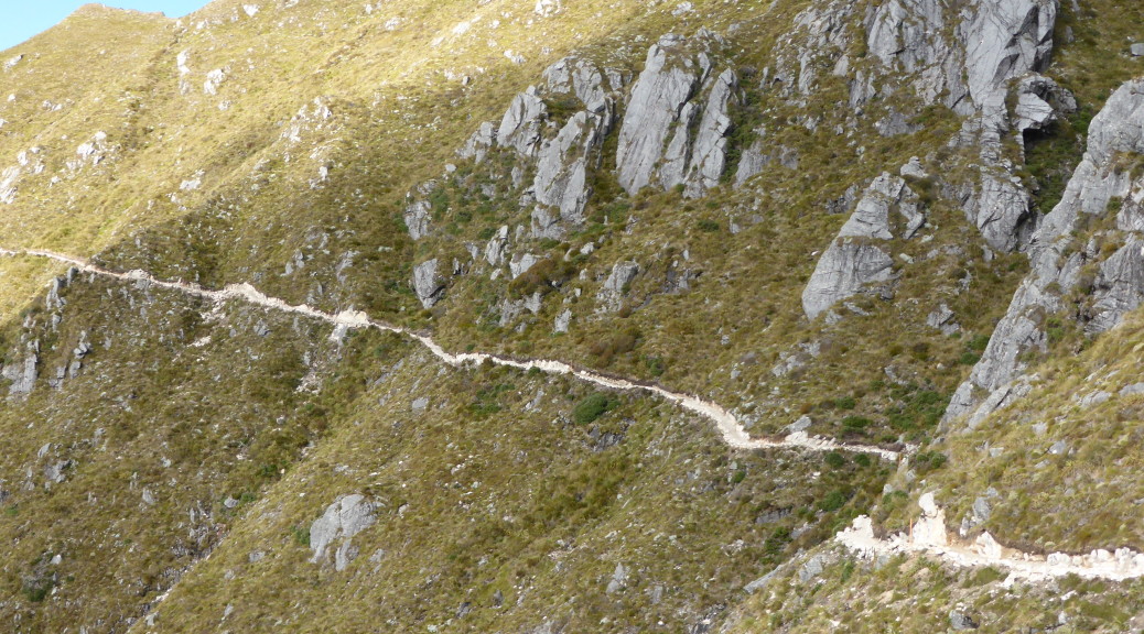
Leaving the hut, it became apparent we were now on brand new trail; as it got steeper, we went through a series of switchbacks. The surface, being new, was quite different with the stones in the gravel seeming much larger. Still, it was all rideable and we were soon out on the ridge making sure not to ride off the edge while looking at the views.


Switching over to the other side of the ridge as we continued north, the trail stretched impressively in front of us – a thin white ribbon seemingly just hanging on the sheer hillside. It became clear that this would be the eight hundred metre section where it was compulsory to walk. I’m pretty sure most of it was rideable, but I’m also sure there was no way I wanted to be put in a body-bag at the bottom. Realising that we would have to turn around soon to get back to the car before dark and home for dinner, we left our bikes and walked to the highest point of the trail – keen to see the view and check out what really is some incredible trail-building.


 Looking east towards the Kaikouras.
 Turning around and heading for home.
Needless to say, the return downhill was quality. A bit of a pity I got a small puncture that took many little stops to inflate my tyre before the tubeless finally sealed up; and then I slashed my tyre landing a jump on some rocks with a kilometre to go, damn. Nonetheless, it was a fantastic few hours and I’m well looking forward to the whole trail being open and I hope I get to bikepack the whole thing soon.