Tag Archives: euro2014

Ticking along around more canals

Another advantage of the terrain turning more forested is that it is a lot easier to find an inconspicuous spot in which to wild-camp – so that’s one less thing to think too hard about. I got a much earlier start than my late Antwerp start – but this just meant I was riding when the first heavy shower hit – which is better than packing up a wet tent. I hid in a bandstand in a village square and cooked my breakfast – ingredients left over from having to buy multiples more of things than I really wanted. With the rain gone again, the rest of the morning was very pleasant as I skirted around the town of Diest – the riding a good mixture of trail types and mostly dry by now.

Crossing the huge Albert Canal seems to have been a regular occurrence since leaving Antwerp. One sees all sorts of things floating up or down it and the locks are, of course, correspondingly large. It’s odd seeing barges that have enough space on the aft deck for the captain’s personal car to go along for the ride. This barge today caught my eye – mostly because I don’t often see large process equipment floating down canals.

Photo & Video Sharing by SmugMug

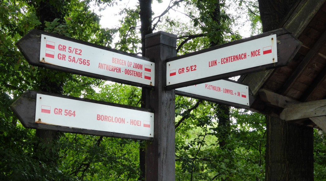
My GR5 navigation was going pretty well, but it does have a sometimes infuriating tendency to try and take the seemingly longest possible route between two points. When I checked a website, it was raving about what a great long-distance walk it was – in the same way the Appalachian Trail is considered. But for all that, in two days and about two hundred kilometres I haven’t seen a single through hiker – or any walker out for more than a stroll. Perhaps they know better than I do about the weather or perhaps this is just a boring stretch and it gets much better further south. The road sections that provide pleasant respite on a bike must really drag by when walking. Still, I could keep going all the way to Nice, theoretically:

Photo & Video Sharing by SmugMug

Water was proving difficult to find for most of the morning – when I finally found a tap on the side of a building, it was turned off. Eventually I found someone that looked helpful – after I’d interrupted the lawnmowing, biking chat ensued and water bottles filled. Just as I reached the centre of Hasselt around two o’clock, the heavens opened again in an almighty downpour that had all the streets emptied for quarter of an hour – the manager of the Indian restaurant kindly extended the restaurant’s awning that I and some others were hiding under. While it didn’t really rain much after that, it did rather put a damper on the rest of the day as everything was soaked and all the fun off-road trails became an exercise in avoiding large puddles and trying not to get me and my things covered in mud. About this time, the trail markings began hard to follow (this tends to occur in large towns/cities as there are so many more places that a blaze could be – so they are easier to miss). I started to take more direct, sealed routes in the hope that I’d stay a bit drier.

Feeding myself is not proving too expensive – I’m manage to fuel all the cycling for between fifteen and twenty euros per day. My calorie intake may need to increase when the hills finally arrive. But for now, I’ve decided cooking for just me is a big waste of time and effort for little saving. Cooking for oneself at home is OK at home, but can get a bit tedious; for me, cooking for myself around a little pot with no-one to talk to just intensifies the solo nature of this trip a little too much. Buying food and sitting eating it at least gives the illusion of some form of social contact!

Tonight’s wild-camping entertainment, while I stretched away the day’s mild efforts, was watching two squirrels chase each other back and forth through the tree-tops. I’d have finished my first set of GR5 waypoints, but the GPS was showing the forest running out – so it was best to set-up camp a bit earlier. I should be past Liege tomorrow – where I’m told the hills start. Looking forward to it, hopefully the last forecast I saw yesterday morning was wrong.

Antwerp and onto the GR5

It’s amazing what a difference a reasonable night’s sleep and some brighter weather can make – also, the scenery and riding got more interesting, so that helps. Alas, I forgot that summertime-full campgrounds are not quiet places – so it was some time before I actually got some sleep. For my sanity, I decided that I’d have an easy morning – a lie in, a bit of internet time to keep this updated and then a leisurely look around the centre of Antwerp (there looked to be some impressive buildings across the water as I sat eating my dinner in a park the previous evening). In fact, as my riding goal for the day was only to bridge the twenty-odd kilometre gap between the end of the GR5A and the GR5 (this apparently is one of the premier long distance paths in the world – connecting Amsterdam and Nice,) I wasn’t really expecting too much.


The view across to Antwerp as the sun sets

My GPS was telling me that there was a bike path connecting the side of the harbour I was on with the city centre. But as it has been reliable so far, I was a bit confused as to why I couldn’t find it. Eventually, I clicked that the big brick box that seemed to serve no other purpose was in fact the top of an elevator shaft & the path must be a tunnel. A gargantuan elevator car in time laboured back to ground level and we descended under the harbour. It must be the longest foot/bike tunnel I’ve ever been in (and still clean somehow) – there since 1932, the original wooden elevators are still there.
Photo & Video Sharing by SmugMug

The Guild Hall and Town Hall seemed, logically, to be the centre of town – but it was still early enough that it wasn’t too busy. I pottered about a bit – easier than in Brugge as there was much more street space and few tourists. My poor planning didn’t really give me much breakfast early on so I sat on a square watching the world go by, over various baked goods. It only took me three days to work out a few things I could do without, so after tracking down a Post Office (third time lucky) my load was the best part of two pounds lighter.


The Guild Hall tower


Town Hall – NZ flag top left

Photo & Video Sharing by SmugMug
A better, sunnier, view of the Guild Hall tower

My route out of the city was just pieced together using whichever cycle trails helped to get me east. A lot of this a bit close to the noise of the motorway, so when I saw the red & white blazes painted I started following these. The same colour-coding that both the GR5 and GR5A use, I guessed this must be some sort of variant that would take me to the GR5 proper. Anyway, it took me away from busy roads and into plenty of woods – and past some palatial homes. A hidden stump jumped out and attacked my pedal viciously, sending me flying – after having sorted all that out (no damage to me or bike, so that’s good). Then it started to rain – for only twenty minutes and the only time I had to put my wet-weather gear on all day! Also the wind was much lighter today. Due to an oversight in my planning, until last night I didn’t have a GPS track for the GR5 (one of the main reasons for finding internet). But all I could find last night for the particular section I want to do is waypoints. With quite some distance between points – up to a mile, it means I’ve had to put into practice all I’ve picked up of the code of trail marking that is left by little red and white stripes on all manner of things. Generally, the stripes are painted (sometimes stickers) on posts (fence post, sign posts, lamp posts etc.) or just on trees. They’re at most intersections and then as often as who-know-who pleases in between – there doesn’t seem to be much consistency here, you can go for kilometres and not see one but at other times they’re on every second lamp post. Of course, things such as posts or trees aren’t particularly permanent, so one has to keep alert – I’m glad I’ve got the waypoints just to keep me going in the right general direction if I manage to lose the blazes.


I’m sure these blazes are much easier to spot at walking pace

All of a sudden – a very big building in the middle of nowhere. Or so it seemed when I’d been riding through the woods a lot. It wasn’t signed, so I didn’t work out what it was. My best guess is a monastery.


The riding today was much better – I even went up a hill! Of sorts – all manner of glee going down the singletrack on the other side, even if it wasn’t for long. Away from all the canals of the last few days, there’s much more of interest to look at – or so I think. And all the houses aren’t so annoyingly immaculate. I also managed to get out my cooking gear for the first time tonight – although it may have been a bit of false economy tonight, as cooking for one doesn’t save much money when all the packs come in sizes at least twice as big as you need. It’s four handfuls of pasta per person, isn’t it?


Belgian Rain & Wind

The ferry seems a distant memory now and it was only two days ago! Getting off the ferry & heading north, it was straight through an industrial zone to get to Dunkirk. An eni plant and then a versalis plant (while there were many spheres, none of them looked as good as the South Sphere) followed by a large steel mill – covering nicely most of my work in the last ten years. Arriving in Europe on a bleak Sunday probably wasn’t the best idea – it was very quiet, but I managed to find lunch before sheltering from the first torrential downpour.

Eventually I was out of France, but strangely the wind and the rain were not impeded by the border. Somewhere along the way, I decided that I would head away from my intended route and go inland to visit the war graves at Tyne Cot. This had almost nothing to do with the part of the GR5-A that I found first was a complete sand-pit and difficult enough to walk through, let alone ride. Thanks to opencyclemap.org, I had a staggering number of cycle routes to choose from as I made for Iepers. I quickly found that war cemeteries, pill boxes, bukers and so forth are regular reminders to the horrors that occurred in this part of the world.

Photo & Video Sharing by SmugMug

As expected, Belgium is flat. I knew that this would not be the most interesting riding, but I figured useful for getting used to bikepacking with a laden bike before I hit any sort of hills. A lot of the riding so far has been alongside miles and miles of canals – most impressively tree-lined. Yesterday particularly I was mindful as I struggled with the cross-wind, that there was a good chance that I may be picked up with my bike and deposited in a canal. I stayed free of canal dunkings – although the rain did return. The Belgian countryside was immaculate, although still seemed to be no-one about at all. I noticed that most of the houses are in pristine condition and seemed quite new, while they were very nice it all got a bit samey. When I arrived in Iepers, I found the town square taken over by a fair – so a good source of food. Wild-camping for the night was a bit close to a busy road to give much sleep – but mostly it was the insane wind that kept me awake.

With the rain around, I could see how quickly the land turned to mud – but it is still near the limits of my comprehension that so many of those lost in World War One were just that. Lost in the mud and never found again. It’s hard to fathom just how awful it all was, definitely puts my struggles with the wind and the rain into perspective. One such lost soldier was my grandfather’s uncle, Stanley. He’s the only reasonable direct relative of mine that I know of that died in WWI – Trish had given me the details of where to find his inscription, so I could spend more of the short time I had at Tyne Cot in contemplation.


One for the family

I picked my way through the myriad of cycle routes available, towards Brugge – a city that has long been on my list of weekend trips away, but for some reason was never ticked off. Immediately it was obviously older than most of what I’d been seeing in Belgium and therefore the buildings were much more haphazard in their appearance and more charming for it. I knew it would be the case, but travelling solo on a bike lends itself to a different type of exploring. Without a safe place to leave my bike, it was difficult to wander aimlessly as I like to do when in a new city. However, I managed to see enough for a brief visit and to enjoy waffles.

Photo & Video Sharing by SmugMug

With still a few hours left before I needed to start thinking about dinner and finding a place to camp for the night, I continued east along canals and across farmers’ fields as the route dictated. The oddity of passing through small villages and finding not a single shop or restaurant, or that matter many people, carried on so eventually I took a marked detour to a larger town, Maldegem, which provided food and shelter for the night. It was here that I noticed that chimes from bell towers in this part of the world are much more melodic, and softer, than I’m used to. With more heavy downpours in the night I didn’t sleep much again and travelling solo means that I don’t have anyone to commiserate about low points with. Perhaps I am, as has been suggested, mad in undertaking all this!


A taste of home

Still, there was more flatland to be ridden before I could find some hills & it wasn’t going to magically just disappear. The previous night, on taking the detour to Maldegem I was surprised to be welcomed back in to Belgium – I didn’t know I’d left. As I rode most of Tuesday near the border I spent a lot of the time wondering just which country I was in. I think I had my first lunch in Netherlands (near Terneuzen – I saw the Dow plant where we used to get butadiene from, but didn’t bother to track down Kelvin Terminals) and my second lunch in Belgium. It was a real mixture of trails today – from paved cycle routes, gravel roads, across fields (always the slowest & bumpiest) and even the odd bit of singletrack. Heading in to Antwerp, I found it surrounded by pear orchards – wasn’t expecting that. After the fifth and heaviest torrential downpour of the day I thought an actual campground best as I was close to the city centre.

Photo & Video Sharing by SmugMug

From a ferry

As I sit on my first cross-Channel ferry crossing in over twenty-seven years, it’s a little difficult to know where to begin writing about this trip that for so long was just a vague “I’ll do that one day” idea nestled in the back of my mind (plus I’m out of practice writing here as months of saving weren’t conducive to having much to write about – May excepted). But with the rather sudden and sad demise of the factory that was Work for me for two and a half years, the prospect of months bikepacking around Europe became a real possibility.

So here I am near the bow of a ferry looking out at a very grey day and multitudes of whitecaps – the remnants of Hurricane Bertha. As I can’t really see more than a mile immediately ahead of me (the French coast has entirely disappeared into the mist), so the next few months look – I have a hazy idea of a couple of places I’d like to go, but by which route I’m going to get there, what I’ll see & who I may meet along the way are complete unknowns. But my bike is loaded up, as below, with hopefully everything I’ll need (one can hope) & no doubt with things I’ll quickly find are just deadweight and can be given away or posted home.

Since work finished ten days ago it’s been a flurry of giving things away, moving what remained to London, enjoying the always great hospitality of cousin Trish & visiting other family, working through the at times daunting pre-departure to-do list, a couple of day-trips into London visiting NZ friends (some resident, some visiting) – the WWI commemorations are well worth seeing, completing the puzzle of packing a mountain-bike for three months away and then saying goodbyes.

After a Windows 8 (what was I thinking?) induced meltdown the night before departure, I finally set off Saturday afternoon by train to Canterbury. From there it was a pleasant thirty mile ride along National Cycle Route 1 to Jan’s (Trish’s sister) house just north of Dover. While mostly on very quiet roads, a little part of the route was off-road. For the largest part it was nice riding through the scores of Kentish apple orchards & the blackberries I found were by far the biggest and juiciest I’ve seen this summer – fighting the nettles were well worth it for the haul I got for dessert that night. Only when the route turned towards a stiff southerly was progress earned – that meant the last hour or so from Sandwich south through Deal (which I thought surprisingly nice – on the sea front anyway) was slow.

Photo & Video Sharing by SmugMug

After a big cooked breakfast (in part, I think three months of cycling is just an excuse to eat a lot; unfortunately, my bike seems to put on weight quicker than I do) it was out into the gusts & rain – finally getting to try out my Ground Effect three-quarter length rain pants (very good so far) – as I made the few miles to the ferry terminal. An advantage of taking a bike on board is that you are the first vehicles into the cavernous deck – & therefore you get your choice of seat upstairs (there are no foot passengers on this route to Dunkirk).

Well Dunkirk is nearing, apparently – soon I’ll be heading north to Belgium, a country I’ve meant to visit for sometime. I may stick to the GR5A route all the way to Brugge, but the opportunity to make quite a detour inland to Tyne Cot cemetery to see the memorial of the only direct relative I know of that was lost in WWI is quite a draw. But, today may be a good wet day to sit eating & drinking copious amounts of waffles and hot chocolate.