Category Archives: national park

A40BPT1 – Hokitika to Ces Clark hut (Paparoa)

Eight weeks earlier I got a speculative “I’m flying to Hokitika and biking to Nelson over ten days, what are you doing?” call out of the blue from Pete. As it happens, not enough that I didn’t quickly sign up for riding three of the best multi-day (if you take your time, which we were planning to do being late-winter touring) bikeable trails in the country. It also helped that it made the long drive for the preceding weekend’s plan (which was postponed due to all the rain) far more worthwhile. So it was that I came to pick Pete up from Hokitika airport on a bleak West Coast afternoon – which just happened to be a notable, but quiet, birthday for me.

Over a suitably extravagant birthday dinner, the plan was reviewed – hoping to ride the Paparoa, Denniston Shortcut, Old Ghost Road, Heaphy and Rameka routes late in winter, we put in plenty of slack and options should the inclement weather continue (although the forecast was remarkably good), either of the two major rivers we had to cross be impassable, or other mishaps befall us. Back to load the bikes – it was summer that I’d last bikepacked, so there were far more layers and general touring gear to find a home for. Rain overnight kept me awake a bit, but the day dawned without it.

Pleased to have the bags back on, and keen to see how a suspension fork goes on these technical trails. I survived rigid last time, but I suspected I’d enjoy the change to plushness.

The day’s destination – them there hills.

A flat warm-up along the highway to Kumara Junction, somehow I managed to soon fall off. Trying to get on the footpath to avoid the traffic on a narrow bridge, the angled curb was far greasier than I expected and away went my front wheel. A bit of a wound on my knee to clean out and cover, actually using the always-carried, but seldom-used, first aid kit. Annoying, but as that was my only fall on a trip that included some tricky trails I’ll take it. Oddly and amusingly, one of Pete’s water bottles sheared clean in two on one snack stop. Left me wondering why I was carrying two large bottles on the Coast, where drinking water is abundant.

We joined the West Coast Wilderness Trail along the coast to Greymouth, where it took an age to buy a hut ticket.

A cruisy hour and a half up the Grey River valley and the short ascent to Blackball where the last shop before the trail provided us with more snacks. Apparently the road to the southern trailhead was closed due to a slip, but we expected we’d get past it. Strangely, for all the Road Closed Ahead warning signs and closed gates, we never saw a Road Closed sign as we approached the Smoke Ho carpark.

Oh, is that it? Of course, DOC *eyeroll. We saw much worse than this on, open, main West Coast roads. Clearly, we passed this easily on bikes.

One wonders how much the small communities vested in such trails suffer from disproportionate risk aversion. Such a waste after all the resources spent on these facilities in national parks. This ridiculousness meant the carpark was empty, and we had the whole amazing trail and huts to ourselves.

Time for what must be one of my favourite climbs – the old Croesus pack track.

Ooh, this is new and more colourful than I’m used to for such things.

Much of the two hour, ten kilometre climb is graded like this (around six percent) and the surface is so long embedded that it holds up well in the local climate.

A couple of bridges to cross before following the true left of Blackball Creek for some time.

Love the moss and general green – so nice to be back in the bush, I miss it.

There used to be a hotel here. Heading for that ridge up there.

Bits of the trail are a bit chunkier.

Actually, a lot of the trail is more technical – but I was having too much fun trying to ride as much as possible to stop and take photos. There are plenty of little stream crossings in and out of bends in the track – these are the most tricky parts. Heavily loaded and with not much time on a bike recently, I was well pleased to clear ninety-nine percent of the climb; satisfying, and very engaging riding.

Emerging from the bush, almost there.

Top Hut, perfectly good overflow shelter if the main hut happens to be full

We arrived at the hut in plenty of time to enjoy the views, get the fire going, appreciate a great day getting into the trip and eat a lot of the food we’d dragged up the hill.

Over the Grey River to Lake Brunner and the Southern Alps beyond.

Whanganui River Paddling

A multi-day trip down the Whanganui River has long been on the list of “non-biking NZ trips I really must get around to doing one day”. So when friends Josh and Victoria invited me along over Hawke’s Bay Anniversary long weekend, I quickly signed up. Arriving at Taumaranui Canoe Hire, we set about packing three days’ worth of supplies into the provided small barrels and were pleased to not have to put our tents up that night – a shipping container providing bunks and shelter, and no need to pack-up wet nylon after a clear night.

Weather looking good first thing near Taumaranui.

Briefing done, we were off in a van for a couple of hours, sparking many “I’ve ridden down/up this backroad” thoughts. Putting in at Whakahoro, we managed to get ahead of the dozen or so other canoes and set off down the river. With the river high, the current assisted us well all weekend and the rapids were a little less intense than they may have been. There began ninety-odd kilometres of floating down the mighty Whanganui.

The weather was kind, Friday being wonderfully warm and sunny, the following two days more overcast. Even better, the wind was negligible – only occasionally on the nose, often behind us. It made for some blissful stretches of simply just drifting downstream taking in the birdsong and native bush crowding in at the banks.

Short stretches of rapids kept things interesting, but we all managed to stay out of the water – even if the water didn’t always keep off us. Unfortunately, no photos of these fun times – it not being nearly as quick to secure one’s phone as on my bike.

We enjoyed stopping at each campground along the way to stretch our legs and eat – such a river trip provides far more opportunity to carry excessive amounts of food over a bike! How far we had to clamber up to the tent sites and shelters giving further indication just how high this river gets in times of flood. All the campsites we stopped at were in special locations – I think it became a case of, how could they not be?

At John Coull, the hut was full and provided opportunity to chat to various people we’d seen on (and in some cases, in) the river during the day. We nabbed a sweet tent spot and enjoyed snacks while playing cards and keeping an eye on the river. Dinner done and well into twilight there were plenty of native bats to watch darting around in the sky catching their meals. Once dark enough, a good number of glowworms were to be spotted too.

We awoke to an eerily misty morning. The cloud stretching down the small valley across the river particularly memorable.

A leisurely breakfast.

On our way, the cloud soon began to burn off and another enjoyable day on the river commenced.

Conquering the tricky landing, it was time for the obligatory walk up to the Bridge to Nowhere. Bit odd going there both without a bike, and twice in six months. But always a strange sight.

Suddenly, a substantial concrete bridge over a deep canyon.

Managing to embark with no spills from the slippery rock, we popped across to the true right and the next campsite – a far more pleasant lunch spot. The afternoon cleared nicely for the second half of the day’s paddle.

Camp for the second night was at the private campsite at Ramanui. It had a number of advantages over the DOC one across the water at Tieke, for the same price – gas burners, running water, hot showers, walking access to a bar (at neighbouring lodge), and quad-bike gear ferrying amongst others.

Contemplating the Matemateaonga Track start/end and whether I’d ever return to walk it (or hike-a-bike it, remembering this video), from the comfort of the lodge balcony.

The forecast rain fell early and overnight, so we got the comfort of decamping in the dry before the last three hours of paddling to our Pipiriki end. Soon we were in a long canyon that was quite slow moving – giving ample opportunity to linger and appreciate the surroundings.

At Ngaporo Campsite, taking the opportunity to work through more snacks and check the rapid below.

We’d been warned of three sets of rapids on this last stretch, that above being one of them – it was no worse than ones upstream. I’d spied a cave marked on the topo map, it demanded further investigation.

Somewhere up there, past the mud, is Puraroto Cave.

Curious mud stalagmites from the dripping cave ceiling.

Maybe it wasn’t past the mud, violently shoe-grabbing mud at that.

Mushrooms!

Back in the boats, the next rapid was purported to give a fifty-fifty chance of staying in one’s boat. I got thoroughly soaked, but my wee craft tracked through easily – water washing all over it and me. Good fun, glad it wasn’t a cold day though. With the bush left behind and now with marginal pasture surrounding us, three days on the water was about enough and I was pleased to get out of the last rapid (despite an eddy suddenly sending me off course and almost upstream) and land at Pipiriki.

What an excellent weekend and a long overdue trip down the Whanganui for me. Highly recommended, and not just because so much food can be carried!

Classic Ruapehu District rides

Getting wind of Anton’s planned weekend away mountain biking some classic trails near Ruapehu, it wasn’t long before I’d signed up/invited myself along. It had been a very long time since I’d been on a mountain biking weekend away, but I was keen to ride some of these trails relatively unloaded and on a squishy bike for a change.

First up, thirteen of us piled into the shuttle to the start of the Bridge to Nowhere trail on a misty and wet morning. Thankfully the heavy rain overnight had ceased. In hindsight, there was plenty of time to have ridden the thirty-four kilometres from Raetihi to the trailhead and I’d have enjoyed that more than a stuffy bus – but I was trying to be at least a little social and fit in, already feeling like a curiosity for not carrying a pack, having small bags strapped to my bike and generally enthusing too much about riding far on a loaded bike.

This is different.

First up, an easy climb for half an hour; the surface was pleasingly good.

Sitting around 600 m altitude for a while, we passed the Kaiwhakauka junction – from here on, I’d ridden on the Tour Aotearoa five years before. This time I was not nearly as tired, or contemplating such a big day. At the Mangapurua Trig after an hour, it was all downhill more or less to the river.

The quarter of an hour dropping four hundred metres to the stream was the best riding of the weekend for me. Chasing and then leading Dan (a fellow ex-NZ Steel graduate who I’d not seen for over twelve years) down the slippery (papa mud is notorious) double track at speed just on the right side of control was excellent. Being much slighter than Dan, I had to work hard to keep up with his momentum; the whole descent was grin-inducing with only the occasional two wheel slides around some of the sharper corners. So. Much. Fun.

Regrouping at one of the small shelters, the misty drizzle set in. Continuing while chatting about bikepacking (again, eyeroll) to Dan we were just cruising. That is until we were passed and I realised we were wasting a good downhill. Unfortunately I timed picking my speed up with one of the big holes we had been warned about. I managed to avoid it, but fell in the process and was fortunate not to be run over. I got off lightly with only a bruised and scraped knee and a sore wrist – along with being somewhat covered in mud, now slower and with my ego taking a hit.

The trail seemed in excellent condition and rounding slips and bluffs was far less precarious than I remembered. We were at the Bridge in no time, close to an hour and a half before we were to meet the jet boat. Plenty of time to linger and appreciate the bush and remoteness; until the rain set in again, that is, and we moseyed down to the shelter above the landing.

Yup, to nowhere.

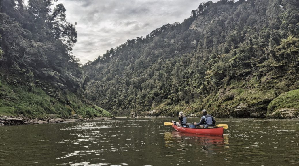
All loaded up for the forty minutes down the river, just missing something.

A few kayakers coming to join us at the landing for a bit.

Eventually we got on the boat…

The rain really set in and it could have been a miserable trip down to Pipiriki. But I was just warm and protected enough that I could still enjoy and appreciate the incredible Whanganui River and its dense surrounds – majestical. Alas, no photos worth sharing with so much water flying around.

Loading the bikes again, wet and muddy we did a number on the bus interior for the tortuous trip to the northern trailhead of the Old Coach Rd. Unloading at Horopito the northerly was very strong and strangely chilly – but once moving, it did blow us quickly along the open part of the trail before we entered the bush. Another excellent trail, and being the old road for horse drawn coaches between two railheads gradually converging to form the North Island Main Trunk, it was well made. Heading in this direction was definitely faster than bikepacking in the opposite one, so less time to savour it and read all the historical signs.

A few planks would do it?

Everyone, that I heard, rated the trail very highly and at only an hour of riding twas a great end to a day out in the elements. Mountain Kebabs downed in Ohakune, forty minutes took us back to Raetihi in fading light and then dark. Noting the propensity of mountain bikers to wear mostly black and not carry lights, I was happy to play lantern rouge at the back in my bright green top and with a couple of blinky lights. I did have to find another dinner at the only option in the village, so I must have done some work – but with only sixty kilometres and little climbing in the legs for the day, it can’t have been much. After the murky and atmospheric day through some remote sections of the North Island, it was a contented and subdued group at the house that night.

Sunday I was excited to return to the 42nd Traverse – the first big, backcountry ride I ever did way back in 2005 and when I met some good riding buddies. Well, it seemed a big, remote adventure back then when I was much less experienced, bikes were far less rideable and reliable, and there was a lot less trail beta out there. That first time it was a whole-day undertaking, but I returned three years later and found it only took two and a half hours with one other. I did remember big ruts and holes, and tough long climbs…

Starting at 900 m, the drizzle quickly had us very wet and muddy – but it was warm. Route finding was much easier – there are trail markers now, who’d have thought? We passed a few vehicles coming back from a morning hunt, the surface was very good. Gone were all the big obstacles; sure, it was damp and possibly slippery – but all easily rideable. An hour of gradual downhill and we were then able to rip down the steeper descent – nothing too wild and more good fun. The seven of us were of a similar pace all day so there was little waiting around, it worked well.

Food time at the halfway point, not the whole reason for a big smile – a good wee adventure in progress.

The only walking section of the whole route. Seeing this, jackets came off despite it still raining – it was that warm.

I’m unsurprised that the climbs weren’t nearly as bad as they seemed over a decade ago – I may be a bit more used to hills. Still eight hundred metres in forty-five kilometres is some climbing. I was just happy to be able to keep pedalling as my gear shifting was playing up; time to replace jockey wheels it turns out. The rain ceased and the afternoon started to clear and warm – in time for the climbing of course. The native forest was far denser and more impressive than I remembered; another fun little ride done as we overcame the wet, wheel-sucking gravel into Owhango.

Completing the vehicle shuffle, we loaded up, said our goodbyes and headed home. A very unusual weekend of biking for me – far more time and distance spent in transit between rides (only rode 110 km all up) than I am used to, I found it a bit weird. But never mind, it enabled riding of some excellent routes with a great crew. Thanks to Anton for an incredible job of organising the whole weekend and marshalling us all – no mean feat.

Finally got to see the mountains we’d been playing in the shadow of all weekend when we stopped in Taupo on the way home for an early dinner.

Strange seeing my under-utilised mountain bike lightly loaded – before it got filthy.

Paparoa Loop

Looking as it did, completely clagged in, after some deliberation we ditched our plan to ride the Paparoa Trail south that day. Raining at sea level, none of us were too disappointed not to be on the exposed tops. So that left us all day to ride the quiet West Coast highway to Blackball, where we’d booked a room in anticipation of riding the trail north in much better weather.

Rain came and went throughout the day, there certainly was plenty of water to see – between the ocean, streams from the hills and that falling on and spraying up at us it certainly was the Wet Coast. The wind and lack of traffic were kind as we ambled south, finding Barrytown’s closed bar and the make-your-own knife experience – we popped into have a look, or just to stand near the blazing forge.

A long cafe stay had us out of the Runanga rain and delivered another pie-light before a short detour to the Coal Creek Falls.

Turning inland and up the Grey Valley, the memorial and panels at the Brunner Mine Disaster site were worthwhile both as a poignant history lesson and more shelter as the rain increased again. As we climbed the largest hill of a flat day’s riding, the skies started to clear. Checking into the Hilton, this worked well for having drinks out the front of the hotel, drying soaked gear and more drinks on the balcony as the sun streamed down and steam started to rise off the streets. It was really quite nice to arrive somewhere early and have time to wander the streets of a place I’ve been a few times, but never really ventured past the Hilton.

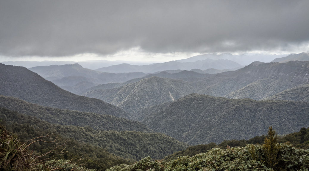
We’d head for those hills in the morning.

Having been hurried through our dinner by the wait staff and successfully avoiding the ’80s music quiz, there wasn’t much for it but an early night. The motley assortment of beds and bunks were surprisingly comfortable, sleep was had and we were off into the hills around seven on Saturday. A solid thousand metre climb ensued in the murk; the first part on the recently widened road to the trailhead.

Just more coal casually lying about.

I’m told the bridges are pretty recent, otherwise the first part of the Paparoa is the old Croesus Track – a historic mining track up and over the range to Barrytown. That means that it’s a rocky surface firmly embedded in the benching that’s been there for over a hundred years of West Coast excessive-rain. That made it a slow, technical challenge of a climb and I loved it.

Out into the alpine at 900 m, Ces Clark Hut immediately appeared.

But we got to this cute wee hut first.

Up at the main hut, we watched as clouds rolled up the valley occasionally allowing us a view of our surroundings.

Out on the tops for the next two hours, this was the most exposed part of the trail – I was particularly glad we didn’t come up here the previous day. It wasn’t raining too much on us and it was only rather windy, not very or extremely windy – so we got off lightly.

This could have been a lot worse with a gale rushing up the slope from the sea, to the right.

There were enough glimpses down to know that it’d be worth waiting for a clear day (or few hours might be all that one could reasonably ask for) to ride through.

Suddenly, there is the Tasman Sea; not often I’m this high so close to the sea.

Moonlight Tops Hut is a big, new hut befitting the track’s Great Walk status. We stopped for lunch, chatting with the group of MTBers that had also left the Hilton that morning – two of the group we’d been leapfrogging most of the morning. As we left another group of five rode in, they were travelling lightly and it sounded as though it had been utterly miserable up there for them on Saturday.

We were now past the high point, the trail now gradually tending down for quite some time along the ridges. Of course there were plenty more little climbs.

Clouds dissipated long enough to see the large escarpment we would ride just behind the ridge line of.

The next hut, also new, was just perceptible left of centre of this shot – we’d approach along the ridge from the right.

Straight into a goblin forest we went as we neared the escarpment. Almost spooky, the mystical light, and the old-growth trees all so gnarled and covered in moss.

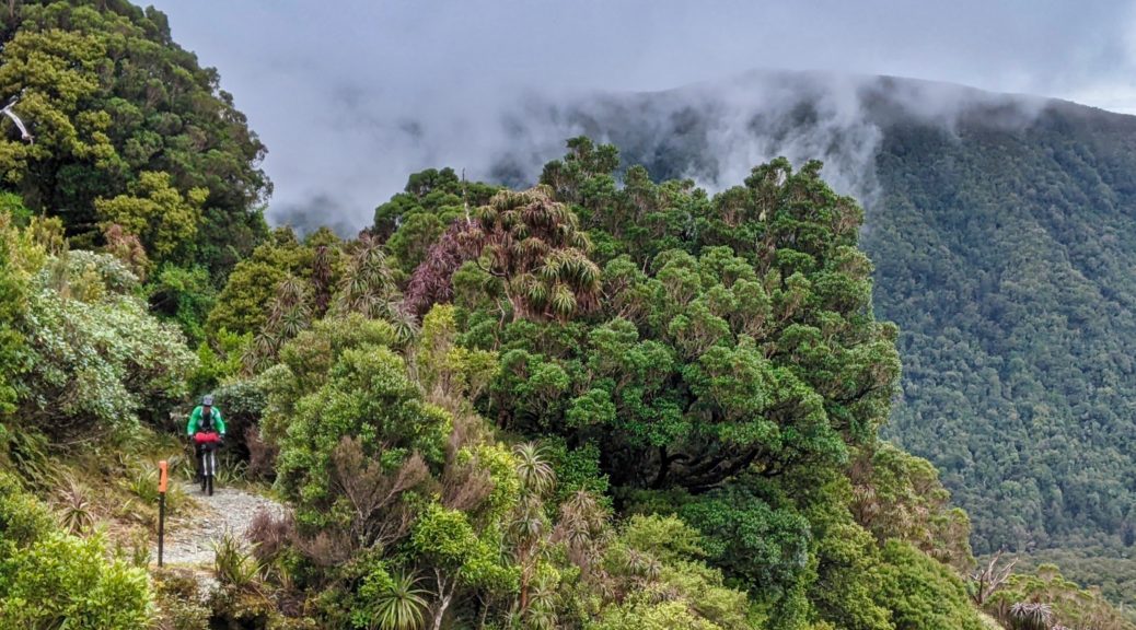
Rachel escaping the lair.

Quite the well made trail in rugged, inhospitable terrain – I was impressed.

Out of dense forest, the view opened and we could just spy a few Pike River Mine structures. I knew it was remote, but this was a level beyond what I was expecting; the sight was fairly incongruous and gave pause to reflect.

That hut’s getting closer, the route to be taken not much clearer.

The descent starting in earnest around here with a big series of switchbacks.

Seemed rude not to make the most of the various trailside seats we found. Lone Hand, on the right of that little range, fair captivated me – upturned towards the heavens as it was.

Stopping at Pororari Hut (another of Great Walk standard), we met our first hikers of the day. The skies cleared to a brilliant afternoon and it was much too pleasant chatting in the afternoon sun to want to roll on down to the valley floor and complete a fantastic day’s riding. But do so, we must eventually. Alas one doesn’t roll along a trail such as this – it was lumpy enough to require some effort with one final wee hill to cross to finish up around five. All my rain gear went on straight away, not because it was raining but to give the midges less to feast on.

What a trail. I thoroughly enjoyed the ride and having company through such scenery. I’m looking forward to returning and seeing it again in – either summer or winter it could easily be a very different ride. No word yet when the Pike29 commemorative side trail will be open, but I suspect before I return; with the climb back up to the main trail, there will be plenty of time for reflection. Back home for more pie-lights (venison and rabbit) and to prepare for the following day’s adventure as I tried to make the most of a clear, but rapidly closing, weather window.