An unexpected invite came from Brent to ride up Mt Erin with a group. So after a good morning MTB ride in the Waipunga Block, a quick lunch and picking up Brent – we were meeting at the foot of the hill. Southwest of Te Mata Peak, where I ride often, Mt Erin is a little taller and on private land – so not usually accessible, except in the notorious long-running, and long running, Triple Peaks event.
There are no trails as such, but a lot of stock tracks, pasture and a gravel access road to the transmitter tower at the summit. Eleven of us met just off the public road and after a bit of organisation set off up the hill. From the cars, I pulled away and looked upward – the summit was not visible. Across a paddock, climbing steeply – it was just rideable with a lot ofeffort and fair amount of line picking. I resolved to buy a smaller, 32 tooth, chainring. We joined the access road and the surface became more manageable than stock trodden ground.
What had been a pearler of a day, clouded over and became rather overcast – but never so much as threatening to rain. We climbed steadily, averaging close to a ten percent gradient – not the easiest on the assorted surfaces. From a distance, Mt Erin looks to have a satin smoothness about it compared to the jagged ridge line of Te Mata Peak. However when you’re on the hill, this is definitely not the case – large, exposed valleys and gullies had me wondering how we would get to the summit without repeatedly losing altitude.
 Looking south, the hill has a few cabbage trees dotted on the exposed slopes.
 Pausing for a breather across one of the valleys seemingly cut in the hill.
 Great clefts cut in the landscape.
Still, we climbed; stopping to open and close various gates was ample opportunity to regroup.
 Lovely folds to appreciate in the landscape. Looking out towards Napier in the weakening light.
 Making a sheep-line out of the valley as our approach was noted.
Most of us took a slight detour from the access road to ride fast grass ridge lines, flying over the pasture, before pausing to consider how to get down to the valley floor.
 Down that slope, deep into that gully.
 Yip, down there.
It was steep, slightly slippery under tyre and with plenty of contour changes to keep one on the ball. Just when you though you had things under control, hard nubs would appear and send one back to the very edge of composure.
 Quite bumpy in the middle.
But the fun descent was handled by all and we were left to climb back to the gravel – which required a fine line and some power just before the road.
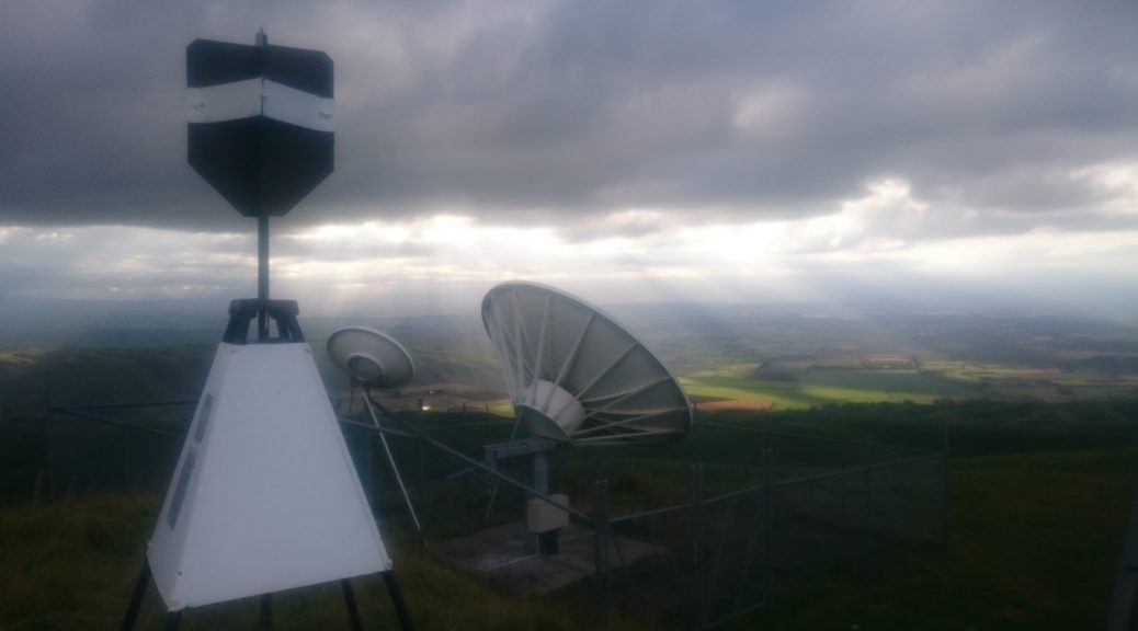
As we neared the apex of our planned route, I hurried off to the summit – I couldn’t go up there for the first time and not go to the peak. What is it there for, after all?

 Te Mata Peak looking a little shorter, and quite different from this perspective, at the left of shot.

 Looking south up the Tukituki River.
From the summit it was all downhill; well, except from the traversing and small bits of climbing. This was all done off the road. So much fun blasting down the hillside, just back from the edge of losing it. One had to be careful with all the flat spots worn into the ground by animals walking back and forth. Sometimes things would get a little loose and you’d be sure you could not ride it, or surf it – just wresting back control in time.
With plenty of this fun over, we were at the bottom of one of the valleys, that was suddenly covered in bush. Staying out of the deep stream course, we followed many animal tracks down the ravine; over roots, around rocks, avoiding dung and the onga onga (stinging nettle-esque shrubbery). Mostly rideable and all enjoyable. After almost a mile we emerged suddenly onto the grass again for more fast descending, a final little climb and a steep hill down to the cars. And beer.
What a great little Sunday afternoon outing. Not so little as far as the climbing went and the steep riding, but short in time. So much fun to see the surrounding countryside from a different perspective while having acres of enjoyment on bikes. I hope I get invited back soon.
 Leaving the Hill behind, over Westshore Bridge I followed my commute route for ten or so kilometres.
 What’s this? Offshore power boat racing. That’s different. Not to mention loud, fast and repetitive.
 I was heading for the coast in the far distance, just right of centre in this shot.
 The crossing of the Esk is at the start of Waipunga Rd, before the hills start. It’s looking a bit lower than a couple of weeks previous, when we had 200 mm of rain in less than forty-eight hours at work (process water at work is taken from the Esk).
 In the mid-afternoon sun (warming enough to only need arm warmers in addition to shirt), the climbing began – as did the views of rolling green hills and distant ranges.
 The largest part of the climb ascends this ridge from right to left, steadily gaining about three hundred metres. It’s very nice.
 I really enjoyed the gradual climb – stopping often to snap photos to share.

 Eventually, the road starts to roll up and down a bit more – gradually climbing overall.
 I paused at the end of Waipunga Rd to look north – this was as far north as my route would go, and also the highest altitude. I had five hundred metres to lose in the twenty kilometres to the coast.
 I turned right onto Kaiwaka Rd – more lush gravel! I headed for the highway to cross it.
 The sun sunk further, setting nicely on this rather out of place patch of toetoe.
 More hills – thankfully I didn’t have to ride them all.
  I kept a watchful eye on my shadow as I lost altitude quickly.
 It seems one can’t really escape work – the pulpmill steaming away on the right; Napier easily visible stretching left across the water, the hills south of Havelock North in the distance.
  I said my goodbyes to cell coverage with one big downhill, a few hairpins and cool rushing air as I blasted down to Waipataki and the sea.
 First I had to work out how to cross the stream.
 Big stepping stones helped, I didn’t fall in; just.


 It quickly became apparent that it was to be another stunning autumn day.
 Pedaling up the driveway, the day’s only sizable hill rose in front of me.
 The highway gets rather close to the coast and the puffing pulpmill comes back into view.
 And just like that I was nearly home, back on my commute route.