When one’s boss suggests a backcountry adventure MTB ride on the return from a work trip, I imagine scuttling the idea is career-detrimental. Not that I’ll ever know – I was hardly likely to say no, was I? I’d not heard of the either the Moki or Rerekapa tracks before Roger mentioned them – deep in the Taranaki hills, both of these trails were built by wheelbarrows, picks and shovels in the early 1900s, but never quite made the transition to fully fledged roads.
Now they’re not much more than overgrown tracks through large stands of native trees (mostly tawa, kamahi and rimu) just above the Waitara River as it starts its journey to the Tasman Sea. Both of these tracks are linked by short stretches of farmland before joining gravel roads – which makes a forty-five kilometre loop, a good day ride. That’s not a great distance for a day of mountain-biking, but the trail is little used and papa surface (particularly through the farms) can be very muddy and slippery with the slightest amount of moisture in the preceding days. The guidebook says “After a week of fine weather, this is the best expert-level adventure ride in Taranaki” – thankfully, it hadn’t rained for days so things were looking up. The book also said the ride would take anywhere between five and ten hours to complete – the only person we knew who’d done it took eight. That’s quite a while for a ride that has little climbing.
With such an adventure in store, Steve was not going to miss out either – so he drove over four hours from Napier to join in the fun. With the roadside organising done and a stable of pretty new bikes, we were off in the early morning sun.
 Token new bike picture – I have a fun bike again.
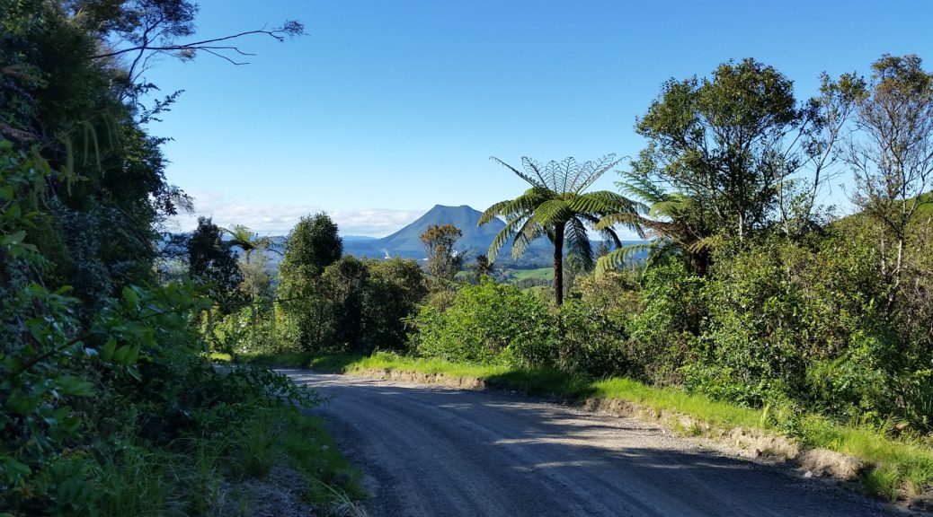
 Chasing horses down the east end of Moki Road – we were heading for the valley in the distance to the right.
 But first a stretch through farmland where Moki Road becomes unformed – but thankfully dry – as the sheep run away. We passed a couple of ruined old houses, still standing – just.
 The valley closes in, as does the native bush.

Reaching a shack that still looks to be used, for hunting I assume, the trail narrowed and went into the bush as the farmland finished. The route wound its way above the river, with short climbs and descents, frequently following the contour to small, rocky stream crossings. Most of the small bridges that had been put in were in such a state of disrepair to be almost non-existent or else unrideable due to slipperiness or the approaches being too tricky for us. The drop off the side of the trail to the river was often precipitous and best avoided.
 There were five wire swing bridges over the bigger chasms – at least these ones had decks. They were considerably easier than the demon wire swing bridge on the Timber Trail approach.
 At least here, the trail is well defined. With a GPS trail and the orange markers to follow, only a few times did we lose the trail temporarily as it faded into nothing.
In the shade of the trees, the trail was still quite slippery in parts despite the lack of recent rain. It was a beautiful ride as the morning slowly warmed; ride is a loose term – it was plenty technical and it became one of those days where after a while you begin to wonder if it’s worth getting back on the bike for such short stretches before another dismount due to some obstacle.
 This bridge was intact and rideable!
Progress was slow – for two hours we barely got above ten kilometres per hour, the average speed being about half that. But it was excellent adventuring and great to be out somewhere where few people ride – not only did we not see any other riders all day, I saw no other tyre marks on the trails. Due to the slowness, the lack of traction and trickiness of it all there were numerous crashes and falls – mostly of the overbalancing, embarrassing-due-to-their-comic-nature type. No injuries ensued and we were quickly over dented pride as it was hard-going and everyone fell at one stage or another.
 Steve trying to work out how much of that slippery approach to another stream crossing is worth attempting to ride as the drop to his right becomes apparent. At least, I assume that’s what he’s thinking as that’s what I thought riding down there.
 There were frequent stops for track maintenance – we cleared numerous branches and trees from the trail, mostly led by Steve, ever the font of energy.
 Finally, we crossed the fifth swing bridge and emerged into the farmland again. Over two hours for less than ten kilometres – that’s Waiuta-level progress.
With a brief stop to refuel, it was through farmland again.
 The view was certainly more expansive out of the trees – Steve taking it in.
 The little tunnel of the ride – the stock were slow to relinquish their positions as Roger approached.
 We crossed to the right side of the Waitara as the farm track improved to was-once-a-gravel-road and things got a bit faster.
Approaching noon, we rejoined proper gravel road at the halfway point. While flat for a while, the only sustained (fully rideable) climb of the day spread us out as Steve carried on with his inexhaustible energy. Seven weeks later it’s not surprising I’ve lost some Tour Aotearoa conditioning, also this was riding of a different intensity – at least, that’s what I’m telling myself.
 Really nice gravel road riding – and about the highest we got all day at a whopping 350-odd metres above sea level.
 With a steep blast back to the valley floor, we found the start of the Rerekapa Track and a suitable lunch stop – suitable except for the young hunting dog that tried to steal most of our food.
Just after one o’clock and with only about ten kilometres to go I was pretty confident we’d finish OK – even if we took it slowly. Following a small stream up through more pasture, it was not long before we crossed it and went back under the cover of the trees. If it was possible, this trail was even more difficult to ride than the Moki track – possibly because it was wetter receiving less sun being in the shade of the hill we were climbing slowly.
 There was no way we were clearing the trail of this tree, and a fair few others – the muscling of bikes around obstacles became more commonplace.
As our speed consistently stayed lower than five clicks, a slight slowing in my line-choice made me wonder if I was starting to get a little fatigued. My legs still felt fine, as they would – they’d hardly done any pedalling; but all the dismouting and lifting/pushing of bike over obstacles was starting to tell on my complete lack of upper-body strength led to me feeling rather worn out. As I felt I was slowing Steve down and contemplated on letting him past I took my second fall of the day. It was by far the biggest of anyone’s – one of those where you put your foot down on something that isn’t quite there. Before long I had fallen off the side of a bank headfirst and then slid even further down again bringing my bike on top of me. So there I was lying, comfortably all things considered, upside down in a dry stream bed somewhat stuck under my bike – very thankful that it was mostly amusing and not at all injurious.
 Thankfully, Steve had hauled my bike off me and I was standing again before a decent photo was taken. My, that trail looks simple – I assure you that there were more slippery rocks there that I misjudged.
The climb over the ridge into the next valley over, we were now amongst the headwaters of the Waitara as we dropped down to the Boys Brigade Hut – which really didn’t look like it was in a great place for a hut. I suppose it had “completely isolated” going for it, but it was next to to an area that looked decidedly swampy.
 The trail disappeared into the grass before heading for the trees again.
There was one surreal hundred metres of so knee-high ferns completely covering the track. Also covering wheels – it went on and on, the feeling of floating on lush green ferns that is.
 Roger emerging from some taller ferns.
We climbed the gate that signified the end of the Rerekapa Track and joined a farm track that was very difficult to ride on as a bulldozer had recently been over it. Thankfully that didn’t last long as we climbed up and joined the main farm track. We spied the Rerekapa Falls off the side of the track – they demanded a side excursion to investigate.


The last bit of gravel track riding back to the car was easy and we arrived back just shy of six and half hours after our departure. We savoured car-beers and an excellent and demanding day of remote and stunning backcountry riding. It’d rate as one of the rides I’ve done with the most amount of sustained technical riding and constant dismounts – brilliant. Thoroughly recommended if you like this sort of ride and can find a good window of weather – as the guidebook says “If it’s wet, find somewhere else to ride.”
 Gaining that little bit of elevation quickly confirmed that it was another glorious day in the Bay. That’s White Island puffing away on the horizon – I really should visit one day.
 While the more magnificient Tarawera Falls were near to our route, this would be the largest waterfall we saw on our trip.
 Looking toward Kawerau and Mt Edgecumbe partway down the descent back to the plains.
 Here’s a view of what I consider the back of Mt Tarawera, and what is definitely Steve’s back.
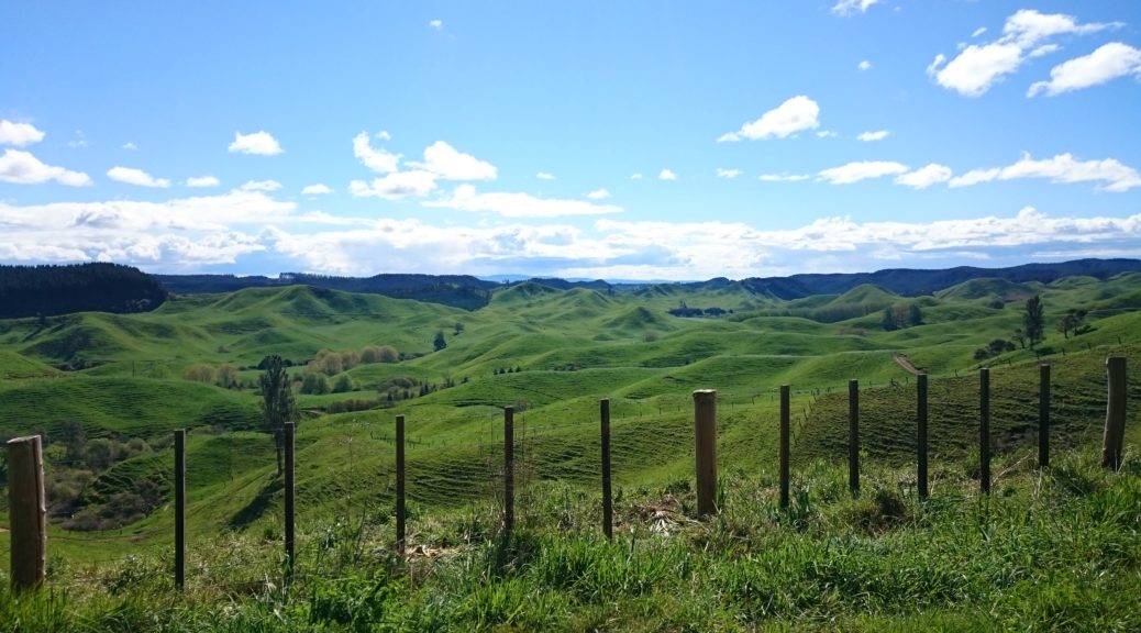
 Waiting for the off; once again Steve, as the accomplished & strong triathlete, had the pleasure of carrying our tent. I travelled lighter than in
  For an event called the Geyserland Gravel Grind, appropriately our first bit of off-road trail was through thermal flats beside the lake. One of my favourite smells, the rotten-eggs of hydrogen sulphide, hung heavy in the air – we must be in Rotovegas!
 I stopped to snap a different perspective of Mt Tarawera.
 Said perspective, looking across Okareka.
 A nice smooth section of trail.
 That done, we were on the shore of yet another lake – Rotoiti.
 It turns out that the turn was marked, somewhat; although the trail is not immediately apparent.
 The buildings were about the only things watching us up here.
 Looking west towards childhood homes – if you squint I’m sure you can see Te Puke there somewhere.
 We fair took over three or so sites (this being about half of our tents) – the campsite was busy with the long-weekend and the popularity of the spot.
 Back on a Bay of Plenty beach with proper sand & all! There’s even Whale Island over there too.
 Plenty of people out enjoying the late-afternoon sun and fishing.
 For some reason, they don’t seem to bale their hay around here – just make little stacks.
 Second to last photo checkpoint – photo with an enthusiastic Southland local. Fascinated as she was by our journey, we also heard a lot of the Wanaka A&P show that was coming up that weekend.
 How could it be so hard to stay on such an easy trail?
 Steve leaning into the wind and fighting his way back onto the path.